")
At 04:00 on 17/09, the location of the storm center at about 22.6 degrees North; 109.3 degrees East, on the southern mainland of Guangdong Province (China). The strongest wind power near the center of the storms level 9-10 (75-100 km/hour), hitches to level 12. The range of wind level 6 to level 8 up, about 200km from the center of the storm; The range of winds level 10 up in about 70km from the center of the storm.
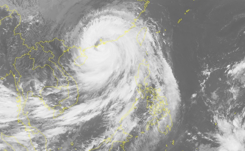
Mangkhut hurricane landed in China
Forecasted in the next 12 hours, the typhoon will move west-northwest, reaching 25-30km per hour, further into southern China's Guangxi (China) and weakening to a tropical depression. At 16 o'clock on September 17th, the tropical depression location is about 24.1 North latitude; 105.8 East longitude, on the southern land of Guangxi (China). The strongest wind power near the center of the tropical level 6 (40-50km/h), up to level 8. The range of wind level 6, level 8 up is about 50km from the center of the tropical depression.
In the next 12 to 24 hours, the tropical depression moving west-northwest, each hour traveling about 25km and weakening into a tropical depression area, to 04:00 on September 18, the center position pressure low at about 24.8 degrees North; 103.5 degrees East, on the southern mainland of Guangxi (China). The strongest wind power of the low-pressure zone drops below level 6 (below 40km / h).
In the Northern Sea of the Northern Gulf (at the north of the 20.0 North latitude, East of the 107.5 East longitude). There is storming today, with the wind power level 6-7, up to level 9; sea waves from 2-3m high; the sea is billowy strongly.
Hazard area in the Northern Gulf in the next 24 hours (the areas have the wind power from level 6 and above): North of the 20.0 North latitude, East of the 107.5 East longitude
Due to the impact of the southwest circulation of the storm No. 6, in Quang Ninh, Lang Son has strong winds level 6, up to level 8. Other provinces in the North and North Central are less affected by strong winds of the storm No. 6.
Disaster Risk Level: Level 3.
In the next 24 to 36 hours, the low-pressure zone moves west-northwest, about 25km per hour, weakening and dissipating in the southern part of Yunnan Province.
Heavy rain warning: Due to the influence of the southwest circulation of the storm No. 6, from early morning on September 17 to September 19 in the northeast with heavy rain with the general rainfall of 100-150mm, separately, Lang Son's, Cao Bang's is 150-200mm. In the North and Northwest Vietnam, the average rainfall is 50-100mm. Ha Giang, Lao Cai, and Lai Chau have the rainfall of 100-150mm. Other areas in the North and Thanh Hoa have the moderate rainfall.
Flood warning: From 17-19 / 9, upstream of the Hong-Thai Binh river system will occur a flood with flood amplitude of 2-5m. During this flood, the flood peak in upstream of the Lo river, Thao river, Ky Cung river, and Bang Giang river at the BD1-BD2 warning level; upstream of Thai Binh River at BD1 warning level.
Flood warning, landslides: High risk of flash floods and landslides in mountainous provinces in the North, especially Quang Ninh, Lang Son, Cao Bang, Bac Kan, Ha Giang, Lao Cai, Yen Bai, Son La, Lai Chau; Waterlogging in low lying areas and in urban centers in Quang Ninh, Lang Son, Cao Bang, Bac Giang.
The warning level of disaster risk due to flood, flood, landslide: level 1.
Author: Wyndham Legend Ha Long